The city's draft flood plan lists 122 assets, from street drainage to seawalls and fire stations. Residents can weigh in at a meeting Wednesday, Nov. 18.
Pompano Beach has published a draft plan for coping with flooding. It names 122 city assets and locations that need work, from drainage on dozens of neighborhood streets to seawalls, sewage lift stations, fire stations and beach access points.
The city wants residents’ views on it at a public meeting on Wednesday, Nov. 18. That is two weeks after up to 9.85 inches of rain flooded parts of the city.
The draft Adaptation Plan is posted on the city’s Adaptation Plan page. A state Resilient Florida grant from the Florida Department of Environmental Protection paid for it, the draft says.
How much of the city floods
The plan builds on a vulnerability study the city finished in 2025. That study modeled nine flood scenarios, from a heavy but common rainstorm to a once-in-500-years storm with a storm surge.
The draft gives these results:
- About 40% of city parcels fall inside the modeled flood area in a 5-year, 24-hour rainstorm, a storm with a 20% chance of happening in any year.
- Nearly 77% are exposed in a 100-year rainstorm combined with a storm surge.
- About 79% are exposed in the 500-year storm with surge.
“Flood exposure is already widespread under more frequent rainfall conditions,” the draft says.
What the draft wants to fix
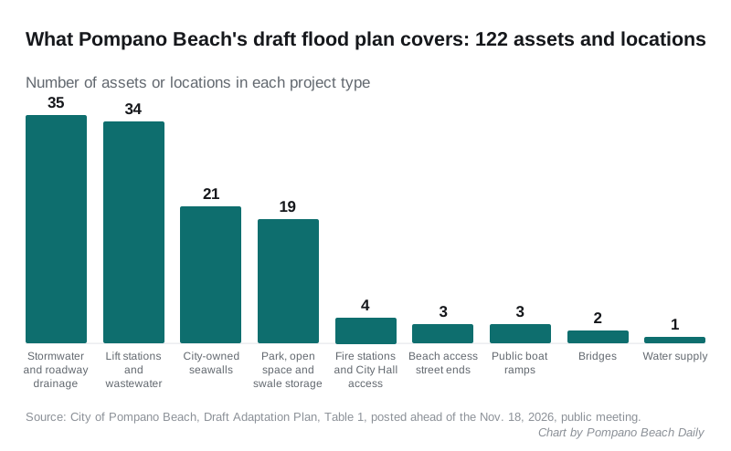
The draft groups its 122 assets and locations into nine project types:
| Project type | Assets or locations |
|---|---|
| Stormwater and roadway drainage | 35 |
| Lift stations and wastewater | 34 |
| City-owned seawalls | 21 |
| Storage in parks, open spaces and swales | 19 |
| Fire stations, City Hall and emergency access | 4 |
| Beach access street ends | 3 |
| Public boat ramps | 3 |
| Bridges | 2 |
| Water supply | 1 |
The plan covers city-owned property and streets, because that is what the city can fund and build. State roads such as Powerline Road belong to the Florida Department of Transportation.
Streets, by neighborhood
The draft names the city streets where water stands after rain or tides back up the drains. Among them:
- Avalon Harbor: NE 23rd, NE 26th and NE 27th avenues. The draft suggests bigger swales and a raised road crown. See our Avalon Harbor guide.
- Blanche Ely: NW 10th and NW 11th streets, and NW 10th Avenue next to the I-95 canal.
- Collier City: NW 23rd and NW 24th avenues. See our Collier City guide.
- Garden Isles: SE 2nd Avenue, SE 2nd Terrace, SE 10th Avenue and SE 7th, 8th, 10th and 11th streets. Runoff from several of them would go to Norwood Pines Park for storage.
- Kendall Green: NE 1st Avenue and NE 17th Court.
- Old Pompano: NE 12th Avenue and NE 11th Avenue at NE 1st Street. The draft proposes buying an open lot on NE 11th Avenue for a detention pond. See our downtown and Old Pompano guide.
- Palm Aire: SW 10th Street along the Cypress Canal. See our Palm Aire guide.
- The barrier island: NE 2nd Street, where the city seawall is overtopped, and NE 14th and NE 16th streets at North Riverside Drive. See our beach guide.
Four problem areas from the city’s 2013 Stormwater Master Plan stay on the priority list:
- Powerline Road and NW 33rd Street
- NE 10th Street and Dixie Highway
- U.S. 1 and SE 15th Street
- SE 15th Avenue
The city plans a new Stormwater Master Plan in 2027, the draft says.
Fire stations, lift stations and bridges
- Fire Station 11, 109 N. Ocean Blvd., is built to Category 5 hurricane standards. Its location may make it hard to reach in a major flood, the draft says.
- Fire Station 63, 120 SW 3rd St., is older and due to be replaced. The draft says the new station should be designed for floods.
- Lift Stations 20 and 21, at 3212 SE 6th St. and 1239 Hibiscus Ave., flood again and again, the 2025 study found. In all, 33 lift stations have some flood exposure.
- Bridges 69 and 70 on SE 9th Avenue could see up to 5.9 and 6.7 feet of water in a 100-year rainstorm with a storm surge, the study modeled.
Parks and the beach
The draft counts 19 parks, open spaces and swale areas that could hold stormwater in a big storm. The parks named include Indian Mound Park, Norwood Pines Park, Pompano Community Park, Hunters Manor Park, Hillsboro Inlet Park and the McNab House and Botanical Gardens.
At the beach, it proposes a citywide dune master plan. The city does not have one now, the draft says.
Three beach access points are singled out, at NE 10th, SE 8th and SE 12th streets. Ideas include:
- angled paths through the dunes, so the opening no longer lines up with the street
- deployable flood barriers, including one near Briny Avenue at SE 8th Street
- open space at SE 8th Street that could hold water during a storm
What is not in it yet
The draft has no price tags. The next phase will rank the projects, add planning-level cost estimates, look for funding and set timeframes, the draft says.
Pompano Beach is also part of Broward County’s RAIN flood warning network. The first phase has up to 10 monitoring points, picked by the city and the county from places with a history of flooding, according to the draft.
What it means for you
- Go to the meeting. It is at 6 p.m. Wednesday, Nov. 18, in the Front Conference Room of the Pompano Beach Cultural Center, 50 W. Atlantic Blvd. You can also watch online through the city’s virtual meeting link.
- Take the poll. The city’s resident poll asks about flooding where you live and which projects should come first.
- Check your street. If water stood on your road last week and it is not on the list above, the meeting and the poll are the place to say so. The full list of assets is in Appendix A of the draft.
- Get ready for the next storm. Our hurricane prep guide covers alerts, sandbags and evacuation zones for Broward County.
Related: road closures in Pompano Beach this week and parks and trails.
Frequently asked questions
What is the Pompano Beach Adaptation Plan?
It is the city’s plan for flooding from heavy rain, high tides, sea level rise and storm surge. The draft lists 122 city assets and locations that need work, including roads, lift stations, seawalls, parks, fire stations and beach access points. It is paid for by a state Resilient Florida grant.
When is the Pompano Beach flood plan meeting?
The second public outreach meeting is at 6 p.m. Wednesday, Nov. 18, in the Front Conference Room of the Pompano Beach Cultural Center, 50 W. Atlantic Blvd. The city’s Adaptation Plan page has a link to watch online and a resident poll.
Does the draft flood plan say how much the work will cost?
No. The draft says the next phase will rank the projects, add planning-level cost estimates, look for funding and set timeframes for the final plan.
Have your say