10 Pompano Beach neighborhoods from the Highlands to Palm Aire: ZIP codes, zoned schools with 2026 state grades, and August 2026 Zillow values.
Last checked Oct. 10, 2026. Sources: the City of Pompano Beach neighborhoods map (PDF), drawn by its Development Services Department; the Broward County Property Appraiser’s neighborhood layer, published by Broward County GIS; Broward County’s city boundaries, address points and 2025-26 school boundaries; the Florida Department of Education’s 2026 school grades; Zillow Research; the Census Bureau; and OpenStreetMap.
Pompano Beach is a city of 114,147 people in north Broward County, according to the Census Bureau’s 2020-2024 American Community Survey. It covers about 24.5 square miles, from the Atlantic Ocean on the east to Florida’s Turnpike and the Coconut Creek line on the west, and from McNab Road and Fort Lauderdale on the south to Sample Road and Deerfield Beach on the north, with a narrow strip, the Highlands, reaching on to NE 54th Street. Going west from the ocean, the city is laid out in bands: the beach and A1A on a barrier island, the Intracoastal Waterway, Federal Highway (U.S. 1), Dixie Highway beside the FEC railway, I-95, the CSX railway that carries Tri-Rail, Powerline Road and the Turnpike. Atlantic Boulevard is the main east-west road, from the Turnpike to the pier.
Three things to know before you look at a listing:
- Four ZIP codes. Of about 19,240 street addresses inside the city in Broward County’s address data, 35% are in 33060, the center and south; 33% in 33064, the north; 17% in 33062, the east side and the beach; and 14% in 33069, the west. Zillow files 33064 under Deerfield Beach, which shares it.
- Three high school zones. In Broward County’s 2025-26 school boundary data, 69% of addresses in the city are zoned for Blanche Ely High, 28% for Deerfield Beach High, which is in Deerfield Beach, and 4% for Coconut Creek High, which is in Coconut Creek. Pompano Beach High, which earned an A in 2026, has no city address zoned for it in the data. School zones do not follow city limits or ZIP codes; always check one address with the district’s Find My School tool.
- Neighborhood names are official. The city’s own map names about 40 neighborhoods, and this guide uses its names. See our schools guide for every school in the city.
The areas at a glance
Typical home value is the Zillow Home Value Index for the area’s ZIP code in August 2026: a modeled typical value for the middle third of homes, single-family homes and condos together, not a sale price. It is a ZIP code figure, so it is the same for every area in that ZIP code. School grades are the Florida Department of Education’s 2026 grades. The areas are listed north to south.
| Area | ZIP | Zoned high school (2026 grade) | Typical home value (ZIP) | Guide |
|---|---|---|---|---|
| Highlands | 33064 | Deerfield Beach (C) | $363,121 | Highlands |
| Cresthaven | 33064 | Deerfield Beach (C) | $363,121 | Cresthaven |
| Loch Lomond | 33064 | Blanche Ely (C) | $363,121 | Loch Lomond |
| Avalon Harbor | 33062 | Deerfield Beach (C) north of about NE 16th St., Blanche Ely (C) south | $473,144 | Avalon Harbor |
| Collier City | 33069 | Coconut Creek (C) south, Blanche Ely (C) north | $231,728 | Collier City |
| Downtown and Old Pompano | 33060 | Blanche Ely (C) | $429,678 | Downtown and Old Pompano |
| Harbor Village | 33062 | Blanche Ely (C) | $473,144 | Harbor Village |
| Beach | 33062 | Blanche Ely (C); a few addresses at the north end, Deerfield Beach (C) | $473,144 | Beach |
| Lyons Park | 33060 | Blanche Ely (C) | $429,678 | Lyons Park |
| Palm Aire | 33069 | Blanche Ely (C); about 30 addresses, Coconut Creek (C) | $231,728 | Palm Aire |
For comparison, the citywide Pompano Beach figure was $351,953 in August 2026, down 1.9% from a year earlier. On the year, 33062 was down 0.2%, 33064 down 0.9%, 33060 down 1.3% and 33069 down 6.2%. More in our home prices guide.
Map of the areas
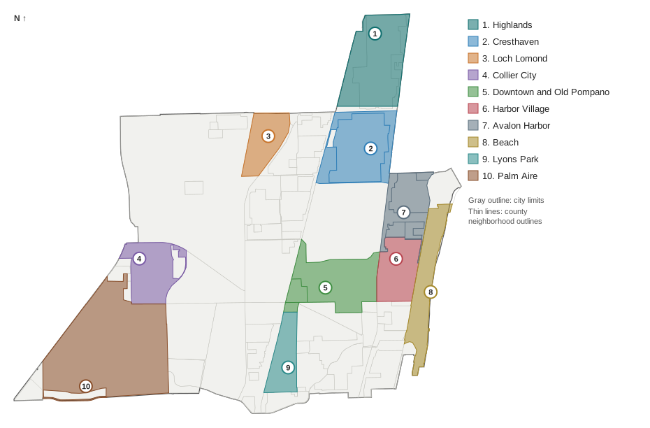
Map by Pompano Beach Daily. Neighborhood outlines are from the Broward County Property Appraiser’s neighborhood layer, the Highlands is the part of the city north of Sample Road as the city’s map shows it, and city limits are from Broward County GIS.
The areas
Highlands. The northern tip of the city above Sample Road, about 790 acres between Deerfield Beach and Lighthouse Point, with North Pompano Park and a county scrub preserve. The only area here where every address is zoned to middle and high schools in another city.
Cresthaven. About 746 acres between Copans and Sample roads, from Dixie Highway to Federal Highway, with the most street addresses of any area in this guide and its own elementary school.
Loch Lomond. A wedge between the CSX railway and I-95 south of Sample Road, with the Pompano Beach Tri-Rail station at its edge and the shortest drive to an I-95 exit of any area here.
Avalon Harbor. The waterfront between Federal Highway and the Intracoastal from Harbor Village to NE 24th Street, with three city parks, split almost evenly between two sets of school zones.
Collier City. About 430 acres in the west, north of Atlantic Boulevard, with Charles Drew Elementary, McNair Park and a county branch library, and the shortest drive to the Turnpike.
Downtown and Old Pompano. The original center north of Atlantic Boulevard, with City Hall, Pompano Beach Community Park, Kester Park and Founders Park.
Harbor Village. Between Federal Highway and the Intracoastal north of Atlantic Boulevard, with a Publix and an Aldi inside it.
Beach. The barrier island between the Intracoastal and the ocean, with the public beach, Fisher Family Pier and Route 11 buses along A1A.
Lyons Park. South of Atlantic Boulevard between Dixie Highway and Cypress Road, with Cypress Elementary and the shortest drive to Fort Lauderdale-Hollywood International Airport of any area here.
Palm Aire. The southwest corner, about 1,706 acres around golf courses between Atlantic Boulevard and McNab Road, the largest area in this guide.
How Pompano Beach compares with its neighbors on taxes, schools and home values: Pompano Beach vs. Lighthouse Point vs. Coconut Creek vs. Oakland Park.
How we built this
We named only areas a public source places on a map. The sources were:
- The city’s neighborhoods map. The City of Pompano Beach’s Development Services Department drew the neighborhoods map (PDF) in June 2012. It names about 40 neighborhoods with their edges, and every area in this guide uses its name and edges. We chose 10 spread across the city, from the Highlands in the north to Palm Aire in the southwest. We left out mostly nonresidential areas the map names, such as Pompano Airpark and the Andrews Industrial District.
- The Broward County Property Appraiser’s neighborhood layer, published by Broward County GIS, which draws 72 outlines inside the city. We used its outlines for each area’s acreage and to count addresses, joining pieces where the city map draws one area around several of them: Downtown and Old Pompano joins three, and Avalon Harbor four. The county layer files most of the Highlands under another name, so for the Highlands we used the city’s own line, Sample Road.
- OpenStreetMap place names inside the city include Pompano Beach Highlands, Harbor Village, Lyons Park, Palm Aire, Country Club Isles and Collier Park, matching the areas here. © OpenStreetMap contributors.
- Broward County’s address points, about 19,240 inside the city, matched on Oct. 10, 2026, to the county’s city boundary, the ZIP code on each address and the district’s 2025-26 school boundary layers, updated March 2026.
Road distances on the area pages are measured on the OpenStreetMap road network with the OSRM routing engine; bus stops are from Broward County Transit’s published schedule data for summer 2026. No area is described by who lives there, and the guide does not rank areas or give buying advice. Related: moving to Pompano Beach, property taxes, parks and trails and getting around.
Frequently asked questions
What are the neighborhoods in Pompano Beach, Florida?
The City of Pompano Beach’s neighborhoods map names about 40 areas. Our guide covers 10 of them: the Highlands, Cresthaven, Loch Lomond, Avalon Harbor, Collier City, Downtown and Old Pompano, Harbor Village, the Beach, Lyons Park and Palm Aire.
What ZIP codes are in Pompano Beach?
Four. Of about 19,240 street addresses inside the city in Broward County’s address data, 35% are in 33060, 33% in 33064, 17% in 33062 and 14% in 33069. Zillow files 33064 under Deerfield Beach.
What high school is Pompano Beach zoned for?
It depends on the address. In Broward County’s 2025-26 school boundary data, 69% of addresses in the city are zoned for Blanche Ely High, 28% for Deerfield Beach High and 4% for Coconut Creek High. All three earned a C in Florida’s 2026 grades. Pompano Beach High, an A school, has no city address zoned for it in the data.
Which Pompano Beach ZIP code has the highest home values?
33062, on the east side and the beach, at $473,144 in August 2026, according to the Zillow Home Value Index. 33060 was $429,678, 33064 $363,121 and 33069 $231,728. The citywide figure was $351,953.
What are the main roads in Pompano Beach?
I-95 and Florida’s Turnpike run north to south through the city, with Federal Highway (U.S. 1), Dixie Highway, Powerline Road and A1A. Atlantic Boulevard is the main east-west road, from the Turnpike to the pier; Sample Road, Copans Road and McNab Road also cross the city.
Have your say